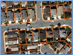
Enhance Online Mapping with ParcelStream™Parcel boundary data has become a must-have data set for mapping applications and location-based products. However, for far too long, parcel boundaries have been difficult and expensive to acquire, integrate, and maintain, until now. ParcelStream™ from Digital Map Products is a nationwide parcel boundary solution that bundles access to parcel boundary data with mapping display technologies. ParcelStream™ is a turn-key solution for integrating parcel boundaries into mapping applications. As location technologies evolve, mapping applications that incorporate parcels are advantaged by offering greater location context, improved geocoding accuracy, and robust map-based interactivity. The ParcelStream™ web service lets you experience the benefits of parcel boundary data without the cost, hassle and learning curve of traditional solutions. ParcelStream™ is a simple and easy way to include parcel boundary content in any web application.
ParcelStream™ is the cost effective solution for the acquisition and display of parcel boundaries. Sign up for a free 14-day trial and experience first-hand the benefits of parcel boundary data and the ease of using ParcelStream™ in mere minutes.
|
 Learn More |