Creating a rich, highly accurate national fabric of broadband coverage with over 300 property attributes & spatial data layers….
Learn moreSpatialStream®
Providing location-related insights for the US
With more than 6 billion server hits per month, SpatialStream is a comprehensive suite of web services and APIs that gives you the location-based data you need. Through SpatialStream, you can stream to SmartParcels®, Building Footprints and more.
Request A Demo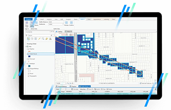
Why choose SpatialStream®
On-demand access
Connect with the entire LightBox catalog to gather specific data insights within seconds.
Calculate with precision
Work with powerful spatial and attribute API used for spatial calculations and enrichment.
Uncover unique data patterns
Leverage LightBox connected data assets, plus access the most up-to-date location, property and address insights.
Tailor your plan
Explore flexible licensing and pricing options—we work to fit any budget, from start-up to enterprise.
Get to market quickly
SpatialStream lets you spatially-enable your app or web portal in weeks instead of months, so you can quickly begin providing value to your users.
Access normalized and current data
All of the content that is delivered through SpatialStream is pre-processed and has already been normalized, so it’s ready to be consumed by your app or portal.
Our databases get updated nightly, so the data in your app or web portal will always be the latest data we have available.
Integration support
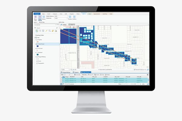
SpatialStream is compatible with ArcGIS, so you’re able to stream the latest data directly into your ArcGIS environment and don’t have to worry about processing or keeping your data current.
No GIS experience needed
Our web services and APIs are easy to implement, so you can reap the benefits of location data without being a GIS expert.
How SpatialStream® is different
SpatialStream applies its knowledge and understanding to each industry to create unique solutions that drive positive outcomes.
Connected Data
Boundaries
Building Footprints
Building footprints are geospatial boundaries that provide the outline of a building drawn along the exterior walls.
Boundaries
Parcel Boundaries
Nationwide parcel boundaries with 300+ property and tax attributes to help you make more confident decisions. Covers 3,100+ U.S. counties including territories, with over 150 million parcels with polygon geometry that is completely normalized.
Property
Historical Tax Assessment
Official record of property from tax assessor from previous years.
Have questions? Want a demo? Let’s chat.
Fill out the form below and a member of our Sales Team will contact you shortly.
Recommended Insights
Data

Geolocation Data – Crucial for Telecommunication Providers’ Expansion and Security
Telecommunication providers will heavily depend on geolocation data to expand their networks, reach underserved areas and combat cyberattacks. This insight…
Data
The Changing Landscape of Data Center Zoning
As the exponential growth of digital businesses and AI continues to surge, the landscape of data centers is shifting. New…
Data

Former AT&T Office to Be Redeveloped
AT&T has signed a new lease for 111,000 square feet at 4807 Stonecroft Blvd in Chantilly, VA, FFX News in…